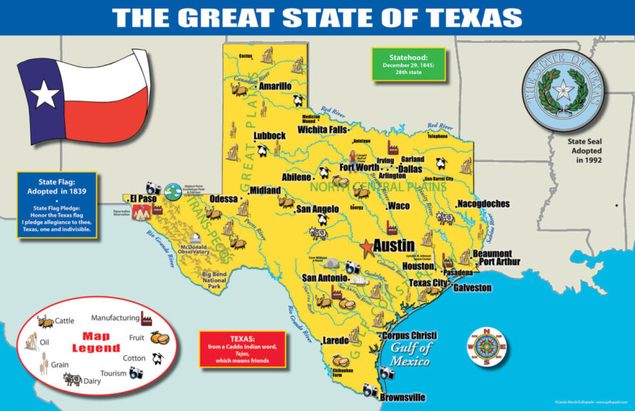
The Texas State Map is great for building map literacy. Students will be able to reference the map of Texas all year long!
The map includes:
• A colorful map of Texas that includes all the major cities
• A map legend that includes where all the major industries are located throughout the state (Cattle, Manufacturing, Fruit, Cotton, Tourism, Dairy, Grain and Oil)
• Origin of Texas name
• History of Texas flag and image of the flag
• Texas statehood date
• Texas state seal
The map is 11” X 17” and printed cardstock paper.
In Store Item
Heavy Wt.
Texas State Map (11×17)
$1.99
The Texas State Map is great for building map literacy. Students will be able to reference the map of Texas all year long!
The map includes:
• A colorful map of Texas that includes all the major cities
• A map legend that includes where all the major industries are located throughout the state (Cattle, Manufacturing, Fruit, Cotton, Tourism, Dairy, Grain and Oil)
• Origin of Texas name
• History of Texas flag and image of the flag
• Texas statehood date
• Texas state seal
The map is 11” X 17” and printed cardstock paper.
6 in stock (can be backordered)
Brand: Gallopade| Weight | 1 lbs |
|---|---|
| Dimensions | 12 × 9 × 2 in |
| Suggested Age | 6+ years |
| Common Use | Child: Elementary to Middle School |
| Safety Warning | None Known |